
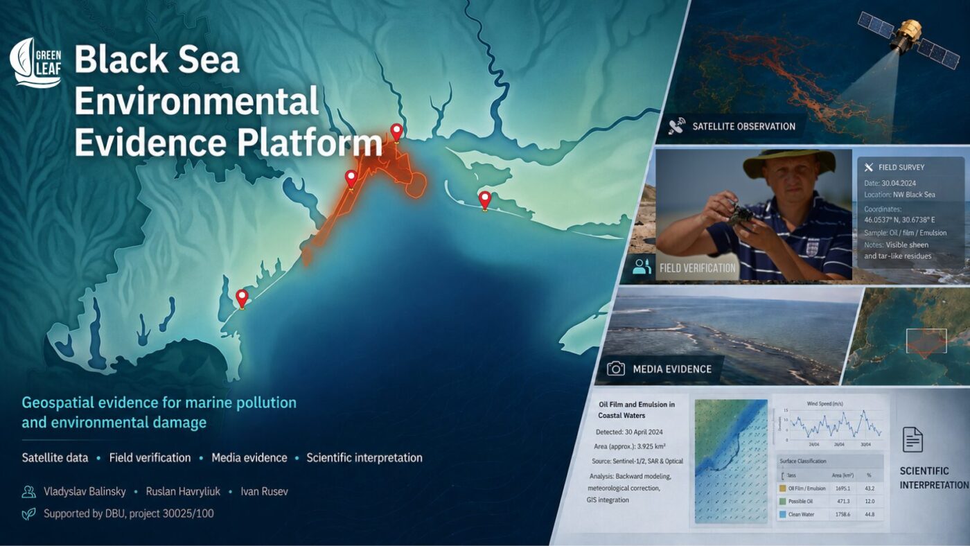
Ukraine documents Black Sea environmental damage using satellite data, field observations, and scientific analysis.
The complete scientific and methodological publication, interactive map and PDF report are hosted by Green Leaf. Open the main platform page.
Documenting environmental damage caused by Russia’s aggression against Ukraine is not only a scientific or conservation task. The quality of evidence collected today will influence whether individual pollution events can be verified, investigated, assessed and used in future restoration and compensation processes.
The marine environment presents a particular challenge. Large parts of the Black Sea cannot be monitored through regular research cruises because of hostilities, occupation, mine hazards, attacks on ports and restrictions on navigation. Under these conditions, open satellite data, field verification along accessible parts of the coast, laboratory analysis and protected storage of original media become central evidence tools.

From a pollution report to a verifiable evidence object
Green Leaf, scientists from Tuzly Estuaries National Nature Park and project lead Ruslan Havryliuk have developed a geospatial platform that brings different forms of evidence into one environment. Each point, line or polygon opens a card containing a date, coordinates, observation method, photographs, satellite material, sources and explicit cautions about the limits of interpretation.
This structure separates direct observation from scientific interpretation and analytical reconstruction. A dark anomaly in radar imagery, for example, is not automatically proof of oil pollution: calm water, natural films and atmospheric processes can produce similar signals. Remote observations therefore have to be compared with optical imagery, weather conditions, field photographs, samples and independent documentary sources.
The platform does not make legal determinations. Its role is to preserve provenance, make verification methods transparent and prevent potentially important evidence from disappearing. Legal qualification remains the responsibility of authorised investigators, prosecutors, experts and courts.
Initial modules: heavy fuel oil and vegetable oil
The first operational version is built around three distinct events. The Volgoneft module brings together material related to the accidents involving the tankers Volgoneft-212 and Volgoneft-239, dated satellite observations, possible residual leak sources, transport reconstructions and field records of heavy fuel oil contamination.
The VO-1 and VO-2 modules address vegetable-oil releases associated with the ports of Pivdennyi and Chornomorsk. They demonstrate how Sentinel-1 and Sentinel-2 observations can be combined with field verification to follow the development, movement and coastal effects of surface pollution.
These cases are not the boundary of the project. They test a common architecture that can be applied to new accidents, damaged vessels, consequences of Russian strikes on port and maritime infrastructure, contaminated habitats, wildlife mortality and other forms of wartime environmental damage.
A vanished surface slick does not mean the impact is over
Black Sea pollution cannot be assessed only through a visible surface trace. Contaminants may settle in bottom sediments and later return to the water column. This remobilisation can create delayed and recurring effects after a slick is no longer visible at the surface.
Basin-scale cyclonic circulation generally moves counterclockwise, but the pathway of any specific event depends on wind, waves, local currents, mesoscale eddies and stratification. The platform therefore does not apply one transport scenario to every incident; each event is evaluated separately.
Explore the interactive map
Open the map in full-screen mode. Click a map object to review its sources, methods and scientific limitations.
Why the platform matters nationally and internationally
Georeferenced material collected now may become an initial evidence layer for environmental damage assessment and future state compensation claims. This requires more than publishing an image: original files, dates, coordinates, authorship, transfer history and links between field, satellite and laboratory information must be preserved.
The platform also highlights the practical needs of Ukrainian researchers: access to satellite archives and computing resources, laboratory capacity, equipment, protected repositories and support for safe field missions. Cooperation between Ukrainian and international scientific and environmental organisations can make a direct, long-term contribution in each of these areas.
Related institutional and project materials from the National Ecological Centre of Ukraine are available through the SUNDANSE project page.
Contributors and responsibilities
- Vladyslav Balinsky — remote-sensing methodology, Sentinel-1 and Sentinel-2 interpretation, scientific mapping, field verification and evidence-system architecture.
- Ruslan Havryliuk — project leadership, sample and laboratory-data coordination, integration of results and scientific review.
- Ivan Rusev — scientific leadership of field verification, biological and ecosystem interpretation, and provision of material from Tuzly Estuaries National Nature Park.
How to submit material
Photographs and reports concerning heavy fuel oil, petroleum, vegetable oil, dead or affected dolphins, birds and other biota may be sent to zeleniy.list1@gmail.com. Please include original photographs, the date, the location or coordinates and a short description of the circumstances. Do not place yourself in danger for the sake of documentation.
Main project resources
Complete publication and interactive map on Green Leaf
Download the English scientific and methodological PDF report

The monitoring was carried out with the support of Deutsche Bundesstiftung Umwelt (DBU, German Federal Environmental Foundation) under its programme supporting Ukrainian researchers and conservation professionals. The content of this publication, the interpretation of the data and the conclusions are the responsibility of the authors and do not necessarily reflect the position of DBU.
Funded by the European Union. Views and opinions expressed are however those of the author(s) only and do not necessarily reflect those of the European Union or European Climate, Infrastracture and Environmen Executive Agency (CINEA). Neither the European Union nor the granting authority can be held responsible for them.