At the 26th International Scientific and Practical Conference “Ecology. Human. Society,” dedicated to the 40th anniversary of the Chornobyl Nuclear Power Plant disaster, Vladyslav Balinskyi—Head of the Odesa Branch of the National Ecological Centre of Ukraine (NECU), biologist, chemist, and researcher at the Tuzly Lagoons National Nature Park—presented the findings of a study on the capabilities and limitations of using Sentinel-1 satellite data to detect oil spills and other surface marine pollution. The research has both scientific and practical significance for rapid environmental monitoring, forecasting the spread of pollution, and documenting the environmental war crimes committed by the Russian Federation.
Why One Satellite Is Not Enough
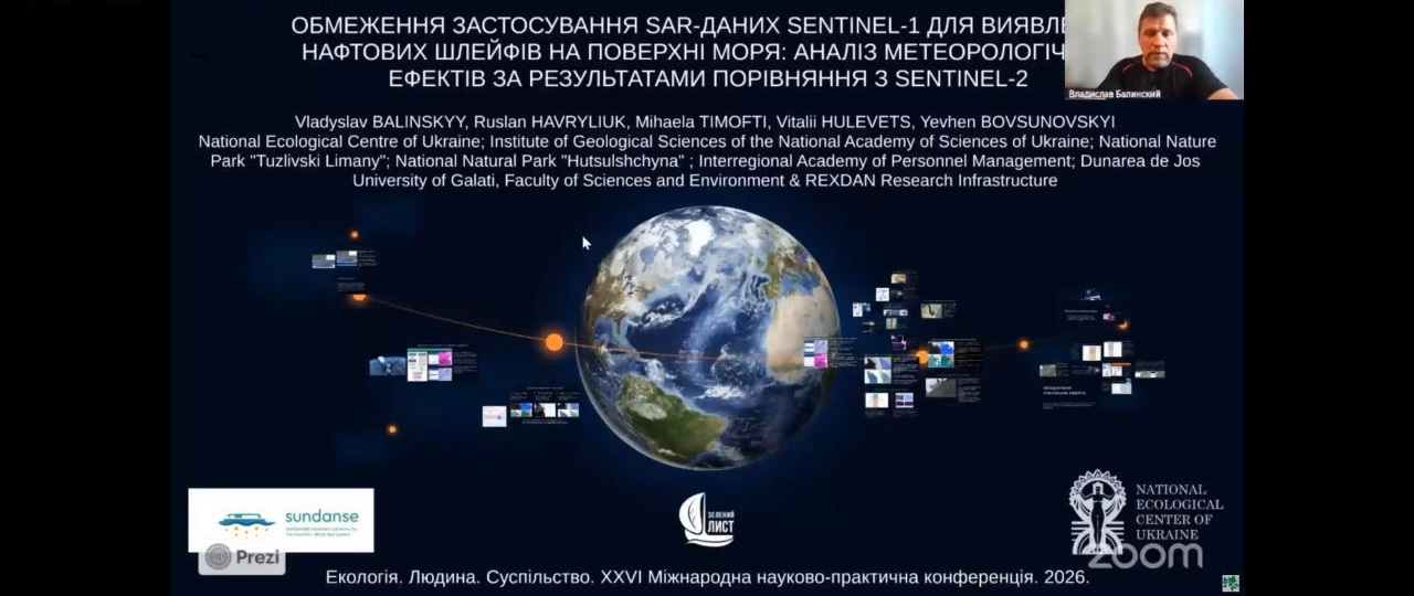
Vladyslav Balinskyi’s presentation, “Limitations of Using Sentinel-1 SAR Data for Detecting Oil Slicks on the Sea Surface: Analysis of Meteorological Effects Based on Comparison with Sentinel-2,” was a natural continuation of research carried out within the SUNDANSE project.
The study is the result of collaboration between an international team of researchers: Vladyslav Balinskyi (National Ecological Centre of Ukraine (NECU), Tuzly Lagoons National Nature Park), Ruslan Havryliuk (Institute of Geological Sciences of the National Academy of Sciences of Ukraine, NECU), Mihaela Timofti (Dunărea de Jos University of Galați, Faculty of Environmental Science and Engineering, and the REXDAN Research Infrastructure), Vitalii Hulevets (Hutsulshchyna National Nature Park, NECU), and Yevhen Bovsunovskyi (Interregional Academy of Personnel Management, NECU).
Balinskyi emphasized that, in the context of war, Earth observation has become particularly important. It enables researchers to collect evidence of environmental crimes in occupied, mined, or otherwise hazardous areas without putting specialists’ lives at risk; conduct retrospective analyses of environmental conditions before and after an incident; establish cause-and-effect relationships; and rely on independent, openly available data from the Copernicus programme, significantly reducing the possibility of evidence manipulation.
The study demonstrated that Sentinel-1 radar data are an extremely valuable tool for detecting surface pollution because they provide observations regardless of daylight or weather conditions. However, using these data without additional verification may lead to false conclusions.
The researchers identified three main situations in which SAR data can be misleading. During periods of strong winds, the sea surface becomes excessively rough, causing actual oil pollution to become undetectable in radar imagery. Under dense cloud cover and complex atmospheric conditions, so-called look-alike features may appear—dark areas that morphologically resemble oil slicks but are not caused by pollution. Another important factor is the thermal stratification of the near-surface atmosphere, which can either mask real pollution or create false anomalies.
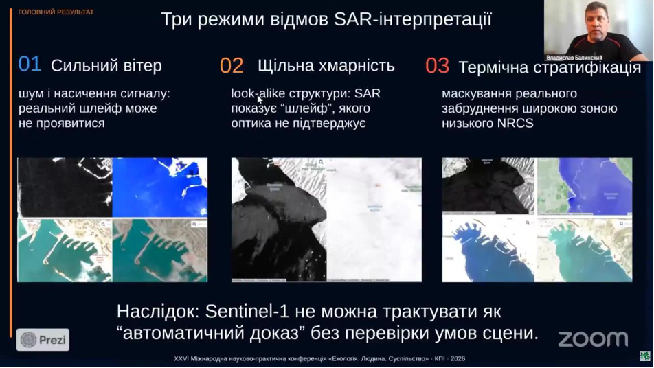
The study’s key conclusion is that Sentinel-1 data should not be regarded as automatic evidence of marine pollution without first analysing meteorological conditions and independently verifying the observations using complementary methods.
A Multi-Sensor Approach Improves Reliability
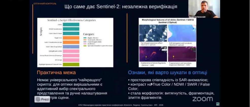
To verify potential pollution events, the researchers applied a multi-sensor approach, combining Sentinel-1 radar data with Sentinel-2 optical imagery and meteorological information.
By analysing dozens of satellite scenes from the areas around Novorossiysk, Anapa, Bugaz Spit, and other parts of the Black Sea, the team demonstrated that only the integration of multiple independent data sources makes it possible to reliably distinguish oil slicks from atmospheric effects.
Particular attention was given to the morphological characteristics of surface pollution. Oil and fuel oil slicks exhibit distinctive patterns: they may elongate, split, merge, and change shape depending on wind direction and sea currents. These morphological features, combined with satellite observations and meteorological data, enable accurate interpretation of SAR imagery.
For the analysis of optical data, the team used various spectral visualisation modes available in Copernicus Browser, including True Color, NDWI, SWIR, False Color Urban, and others. The study showed that no universal processing algorithm exists: the most effective visualisation method depends on the specific scene, illumination conditions, atmospheric state, and other environmental factors. Consequently, each case requires an individual selection of processing parameters.
The Methodology Has Already Proven Its Effectiveness
Particular attention in the presentation was devoted to the practical application of the methodology following Russian attacks on Ukraine’s civilian port infrastructure.
After the large-scale spill of sunflower oil caused by a Russian strike, the researchers used an integrated analysis of Sentinel-1 SAR imagery, Sentinel-2 optical data, and meteorological information to forecast the movement of the pollution.
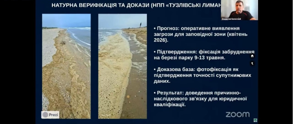
According to Vladyslav Balinskyi, this approach made it possible to predict the arrival of the oil at the coastline of the Tuzly Lagoons National Nature Park with an accuracy of approximately one day. Subsequent field surveys conducted in the park on 9–13 May 2026 confirmed the accuracy of this forecast. Photographic documentation of the pollution served as ground-truth validation of the satellite observations and made it possible to confirm the cause-and-effect relationship between the incident and its impacts on the protected area.
The methodology can therefore already be applied for the operational monitoring of accidental spills, forecasting the spread of pollution, assessing risks to marine ecosystems, and supporting the rapid response of environmental protection authorities.
Science as a Tool for Documenting Environmental War Crimes
The practical value of the research extends far beyond environmental monitoring.
According to the authors, modern Earth observation techniques can be used to document environmental war crimes, assess the scale of environmental damage, prepare evidence for international legal proceedings, support sanctions policy, and detect the activities of the so-called shadow fleet.
The use of openly available Copernicus satellite data ensures the independence of the evidence base, while the ability to conduct analyses without physical access to the affected area is particularly important under conditions of armed conflict and occupation.
The researchers emphasize that advances in Earth observation technologies are creating new opportunities for the independent documentation of the environmental consequences of war and are strengthening Ukraine’s evidence base in efforts to seek compensation for environmental damage caused by Russia.
Further Development of the Methodology
The presented study is a continuation of the development of the differential tracing methodology for dark-core zones, created within the framework of the SUNDANSE project. The methodology enables researchers to identify active sources of marine pollution and trace the origin of surface slicks without requiring physical access to the site of an incident.
An earlier version of the methodology was presented by Vladyslav Balinskyi in June 2025 at the 25th International Scientific and Practical Conference “Ecology. Human. Society” held at the Igor Sikorsky Kyiv Polytechnic Institute. The study was recognised as one of the conference’s three best presentations. The new research significantly expands upon these earlier findings by defining the limitations of SAR data and demonstrating the meteorological conditions under which mandatory verification is required.
Russia’s aggression has created unprecedented challenges for environmental monitoring in the Black Sea. The presented research demonstrates that combining Sentinel-1 and Sentinel-2 satellite data with meteorological analysis and field observations makes it possible not only to rapidly assess the environmental consequences of Russian attacks, but also to build an independent scientific and legal evidence base for future efforts to hold the aggressor state accountable.
Funded by the European Union. Views and opinions expressed are however those of the author(s) only and do not necessarily reflect those of the European Union or European Climate, Infrastracture and Environmen Executive Agency (CINEA). Neither the European Union nor the granting authority can be held responsible for them.